Defense / Military Virtual Terrain
- The Defense Industry was among the earliest to recognizes the importance of virtual terrain,
from as early as the 1970s.
- The Modeling and Simulation Coordination
Office (M&S CO) is a central node of US terrain projects
-
 U.S
Navy
SIMDIS
U.S
Navy
SIMDIS
- a project of the Naval Research Lab in Washington DC
- a set of software tools that provide 2D and 3D interactive display of live
and post processed test and simulation data, including terrain, vehicles and
ballistics
- in military lingo, SIMDIS is government off the shelf (GOTS) software
- has a large number of users throughout the U.S. DOD
-
White Sands Missile Range's
RAGE
- 'Real-Time Advanced Graphics Engine' visualizes the
terrain around a missile test before, after, and even during the test
-
VMASC Virginia Modeling, Analysis and
Simulation Center
- a curious academic/military/non-profit hybrid organization, which does a
wide variety of modeling and simulation projects, some of which include
terrain visualization
- U.S. Army Topographic Engineering
Center's (TEC) [http://www.tec.army.mil/] had an excellent page of Terrain
Visualization Resources, although it was offline as of 2005; another
revision of their famous "Commercial Terrain Visualization Software Survey"
was revised as late as 2008, but then it too disappeared
Off-the-shelf
-
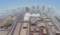
VBS2 (Virtual Battlespace 2)
- One of several "serious games" packages that are based on technology
from the gaming industry, but adapted to the needs of military
training/simulation: battlefields, scenarios, land, sea, and air
vehicles, command and control.
- Price: ($?) negotiated per license; generally locked by a dongle.
- Claims to support "moving trees and grass, ground clutter, ambient
animal life, shadows, dynamic lighting, weather and time of day".
- As of 2011, there is reportedly still some difficulty in importing
real-world data into VBS2, perhaps due to the lineage of the software
from gaming rather than geospatial.
Commercial and Non-governmental
-
 There
are a growing number of people adapting terrain visualization from the Games
field to Defense-related uses. An example is
Breakaway Federal Systems which
has a history as a game producer but now splits their operation between the
game and "serious game" markets. They claim some cutting edge terrain
capabilities such as "generation of accurate, synthetic
urban environments within 24 hours using satellite data" and "geospatially
accurate, highly detailed visual simulations of 3D aquatic environments."
There
are a growing number of people adapting terrain visualization from the Games
field to Defense-related uses. An example is
Breakaway Federal Systems which
has a history as a game producer but now splits their operation between the
game and "serious game" markets. They claim some cutting edge terrain
capabilities such as "generation of accurate, synthetic
urban environments within 24 hours using satellite data" and "geospatially
accurate, highly detailed visual simulations of 3D aquatic environments."
-
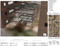 iMOUT,
an Autodesk product that unites CAD, GIS, BIM (building information
modeling) and 3D visualization technologies (as of 2007)
iMOUT,
an Autodesk product that unites CAD, GIS, BIM (building information
modeling) and 3D visualization technologies (as of 2007)
- Not yet explicitly mentioned on the
Autodesk Geospatial Business Unit site
- Very much recognizes virtual terrain as a convergence: "It's different
from [MS] Virtual Earth or Google Earth, [The building] is a BIM model. The
elevator shafts could have come from a mechanical program. The road data
could have come from a civil engineering application. Other data could have
come from CAD, GIS, 3D city models and subterranean utility infrastructure
data."
- SRI's Automatic Population of Geospatial Databases program (1997-2000)
- "The uses for high-resolution, geospecific 3-D site models are rapidly
increasing – fueled by dramatic advances in computer graphics and
simulation. The missing piece is the technology for creating 3-D models
without the need for significant human interaction."
- defense contractor Alphatech
had a Dynamic Database (DDB) project
- "Advanced geospatial representations that describe uncertainty.
Advanced data association algorithms that derive correspondences between
varying geometric descriptions of complex terrain regions. Approximate
Bayesian net inferencing algorithms for geospatial reasoning."
-
Historical
AIS
Terrain Team (later
AIS)
Virtual Cities
(around 2001)
- producing city models, "currently being developed under a Department
of Defense contract for training of the Military's Weapons of Mass
Destruction Civil Support Teams and are also being provided to selected
organizations in the civilian First Responder community."
- they don't say much about how they produce their models, but they do
start with raw GIS layers and use a combination of automatic and manual
modelling
Simulation
- Historically, the Defense Industry has a simulation standard, DIS (Distributed
Interactive Simulation)
- "The primary mission of DIS is to define an infrastructure for linking
simulations of various types at multiple locations to create realistic,
complex, virtual "worlds" for the simulation of highly interactive
activities"
- Sadly, the IEEE DIS standards documents were only available through
purchase.
- DIS/x from Web Simulations,
Inc. is a C/C++ binding of the IEEE 1278 DIS protocol for UNIX and
Windows, free and available in source code
- HLA (High-Level Architecture) is a bigger set of standards, going beyond
DIS
- CERTI is a free
library (GPL) for HLA distributed discrete event simulations.
- as of 2005, the latest acronym is TENA (Test and Training Enabling
Architecture) which people must now struggle to support in addition to DIS
and HLA
Formats
- the military Vis-sim world has a huge number of files formats which are
generally complicated, poorly documented and not widely supported, some of
which are intended for terrain data
- historically developed for use in the ModSAF simulation project, the CTDB (Compact
Terrain DataBase) format was widely used but not widely supported in
commercial terrain database tools due to its relative complexity
- ModSAF (modular semi-automated forces) was obsoleted by
OneSAF Test Bed (OTB) in 2001
- Eventually this evolved into the OneSAF Terrain Format (OTF)
- OTF 4.0 in 2009 suddenly leapt to OTF 8.0 in 2010. It is
generally supported only by high-end Vis-sim software such as those from
Presagis
