SRTM: NASA Shuttle Radar Topography Mission
The wonderful SRTM project has the potential to provide global elevation data
at up to 30m (1 arc-second) resolution, worldwide! For a description of
the project, see the NASA/JPL SRTM
site.
Acquiring
the data
-
 90m (3 arc-second) elevation can be browsed and downloaded from the
USGS EarthExplorer
90m (3 arc-second) elevation can be browsed and downloaded from the
USGS EarthExplorer
- just look under "Digital Elevation: SRTM"
- or directly from their FTP site
files are named according to latitude and longitude
- The GLCF is also a convenient
way to browse and download SRTM data, in GeoTIFF format - for more information,
see the GLCF SRTM page.
They also offer direct FTP
access.
- A very useful server is CGIAR-CSI:
SRTM 90m Digital Elevation Data. It also happens to offer their "version
4" SRTM which has the gaps filled.
- Higher-resolution 30m (1 arc-second) SRTM exists, but since it is only released
for the USA, it is of limited use, generally inferior to existing USGS 30m DEMs
in many ways.
Global 1km data: SRTM30
- SRTM data was used to update the older USGS GTOPO30 global DEM, by averaging
to 30 arc-sec resolution and replacing GTOPO30 heixels between the latitudes
of 60° North and 56° South.
- The resulting data can be
directly downloaded
and is now (as of 2004) the best available global 1km elevation dataset!
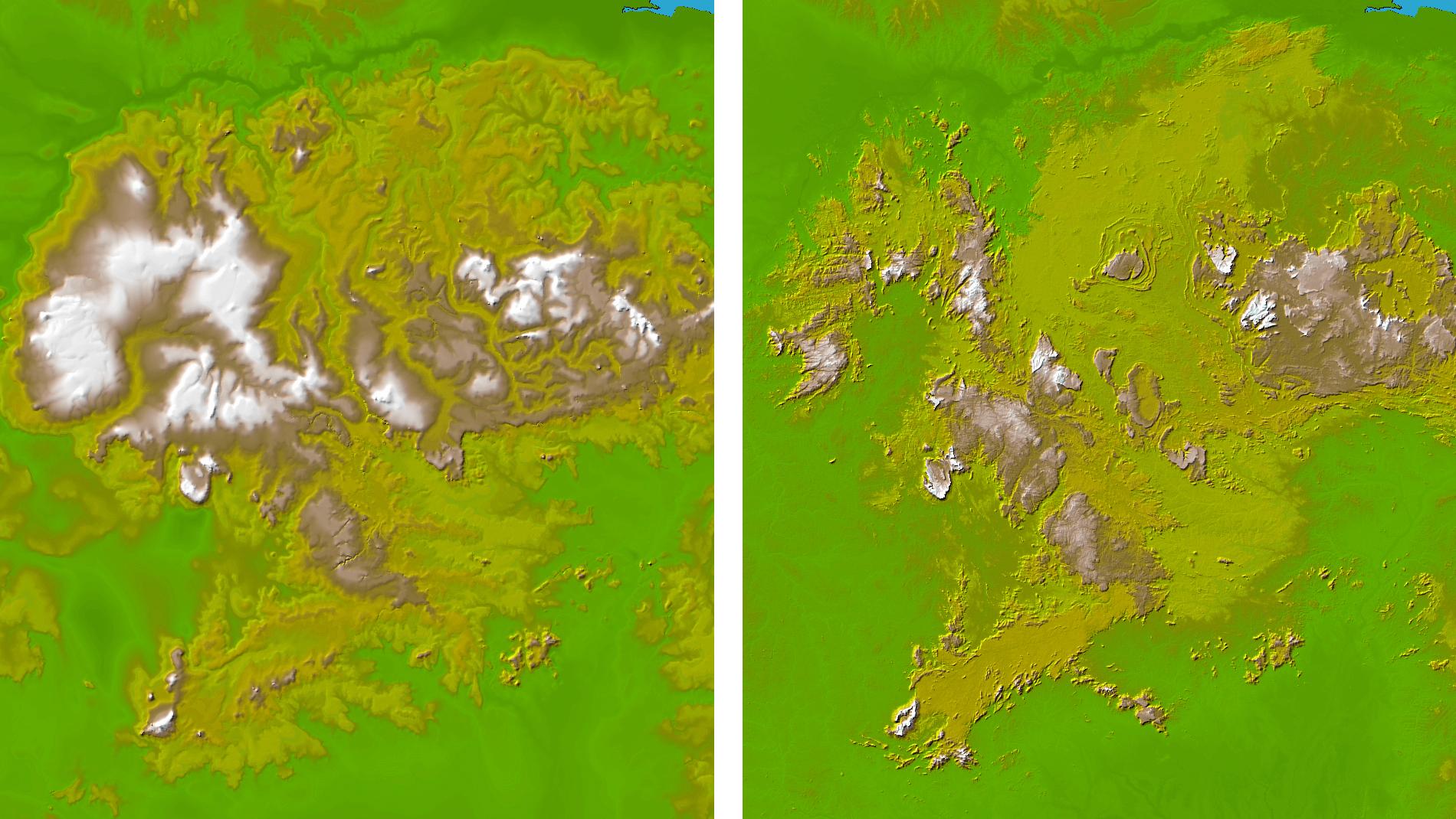
- See the before-and-after improvement in the images to the right - SRTM30
replaces the wild guesswork of previous data with actual measured values
History
- "the Memorandum of Understanding between NASA and NIMA for SRTM specifies
that data processed at 3 arc-seconds (~100m) for anywhere
on the globe will be unrestricted, as will 1 arc-second (~30m) data
for the United States and its territories. Distribution of one arc-second
data for outside the United States will be approved by NIMA on a case-by-case
basis for NASA Investigators, for their use only."
- SRTM data came out first for the USA, but that data is not much used, since
regular surveyed DEMs of higher resolution and quality already exist for the
USA
- International data was released beginning in June 2003
- In late 2005, SRTM version 2 was released. SRTM V2 was "the
result of a substantial editing effort by the NGA and exhibits well-defined
water bodies and coastlines and the absence of spikes and wells (single pixel
errors), although some areas of missing data ('voids') are still present."
- Subsequent improvements have been made by groups such as
CGIAR (see 'Improved SRTM' below.)
Drawbacks
- there were many data quality issues with SRTM V1 data
- overall the issues are too complicated to describe here, but to summarize:
- there is a vertical error of +/- several meters, including water areas,
so that for example oceans are not flat, nor are they "sea-level"
- there are a very large number of holes or gaps in the data, especially
in mountainous areas
- SRTM V2 fixes the water area noise, but still has the gaps
Improved SRTM
- CGIAR-CSI: SRTM site offers
cleaned up, interpolated SRTM data
- Their "version 2" was based on SRTM V1. It has water
areas clipped with shoreline vectors, and voids filled with interpolation.
- Their "version 3" (as of September 2006) is based on SRTM
V2: "Dr. Andrew Jarvis and Edward Guevara of the CIAT Land Use
project, Dr. Hannes Isaak Reuter (JRC-IES-LMNH) and Dr. Andy Nelson (JRC-IES-GEM)
have further processed the original DEMs to fill in the no-data voids. This
involved the production of vector contours, and the re-interpolation of
these derived contours back into a raster DEM. These interpolated DEM values
were then used to fill in the original no-data holes within the SRTM data.
Three additional points have been added over processing in SRTM V2 available
from CIAT: (i) the support for auxiliary information, (ii) the use of a
void region specific processing over a tile based processing, and use of
SWDB V2 water body database."
- Their "version 4" (as of September 2008)
says: "This latest version represents a significant improvement from
previous versions, using new interpolation algorithms and better auxiliary
DEMs. We are confident this is now the highest quality SRTM dataset available."
- Jonathan de Ferranti's Viewfinder
Panoramas site hosts a page about
elevation datasets for
mountain peaks around the world. This page includes SRTM-derived DEMs "in
which the no-data void areas have been filled from the best available
alternative sources.
They are much more accurate than those created by interpolation."
- The included mountain ranges are: the
Himalayas
(including Karakoram, Hindu Kush, Pamir and Tien Shan),
Andes,
Tatra,
Caucasus,
New Zealand,
Japan,
Corsica
- His site also contains detailed interesting information about the factual
and political nature of mountain peak altitude values, which are often very
inaccurate with many sources giving conflicting information.
Tools
- If for some reason you don't want to use the CGIAR SRTM version 3, there
are several software tools for patching the gaps in SRTM (V1 and V2) files,
all of which read .hgt file format in the standard 1-arcsecond or 3-
 arcsecond
tiles that come directly from the SRTM FTP site
arcsecond
tiles that come directly from the SRTM FTP site
- SRTMFill Utility (free,
for Windows)
- fast and easy program for patching NULL-data holes in SRTM DEMs by progressively
in-filling from surrounding data, "quickly making usable data from
unusable DEMs"
- DG SRTM Void Killer (for Windows,
$43)
- works by interpolating the gaps in the SRTM, then combining the result
with GTOPO30 data
- operates on a single tile at a time
- can write back to the original SRTM .hgt file, or to its own DRC format
- BlackArt (free) is generally a
tool for interpolating contour lines, but it also can also patch gaps in SRTM-1
and SRTM-3 data
- VTBuilder (free, cross-platform)
can also load any number of SRTM .hgt files, merge and resample them, and fill
the gaps with interpolation or lower-resolution data