Terrain Software and Projects - Noncommercial
see also: commercial software
and government/academic projects
-
 3DEM
3DEM
- freeware; was once commercial, finally abandoned in 2008, but still
useful
- viewer and converter for DEM files
- both non-realtime and realtime rendering, using OpenGL
- reads DEM, SDTS DEM, NED, GTOPO30/GLOBE, SRTM,
MOLA, Mars DTM,
ASTER, and raw
data
- drapes DRG, GeoTIFF and TMS (TIGER Map Server) images
- merges multiple input file, writes elevation to TerraGen, USGS DEM and
many bitmap formats
- writes textured polygonal scenes to VRML, can save flyovers as AVI or
MPEG
- can display GPS receiver waypoints, routes, and tracks
-
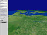
 Biosphere3D
- 3D viewer with significant support for vegetation using plants from
Lenné3D Flora3D
- A unified view from planet to ground level. Limited interaction: fly around, turn layers on/off.
- Data preprocessed
on a command-line with FWTools, 3D models via Collada, Point Shapefiles
for model and plant locations
- Open source, portable design, has a Windows installer, builds with
VC9
- As of 2009, on a contemporary machine, it ran fairly slowly, perhaps related to the heavy GPU usage and
atmospheric rendering
- CSP - The Combat
Simulator Project
- open-source project (GPL) which includes a terrain engine and flight
modelling, with an emphasis on combat
- started February 2001, with slow but gradual development over the years
- as of 2005, supports multiple terrain engines including Demeter and
ChunkLOD
- DG Terrain Viewer
- small terrain viewer for Windows (free executable, C++ source code for
$118)
- reads SRTM 1 and 3 arcsec files, USGS DEMs and DATs, Terrain Base ETOPO
5
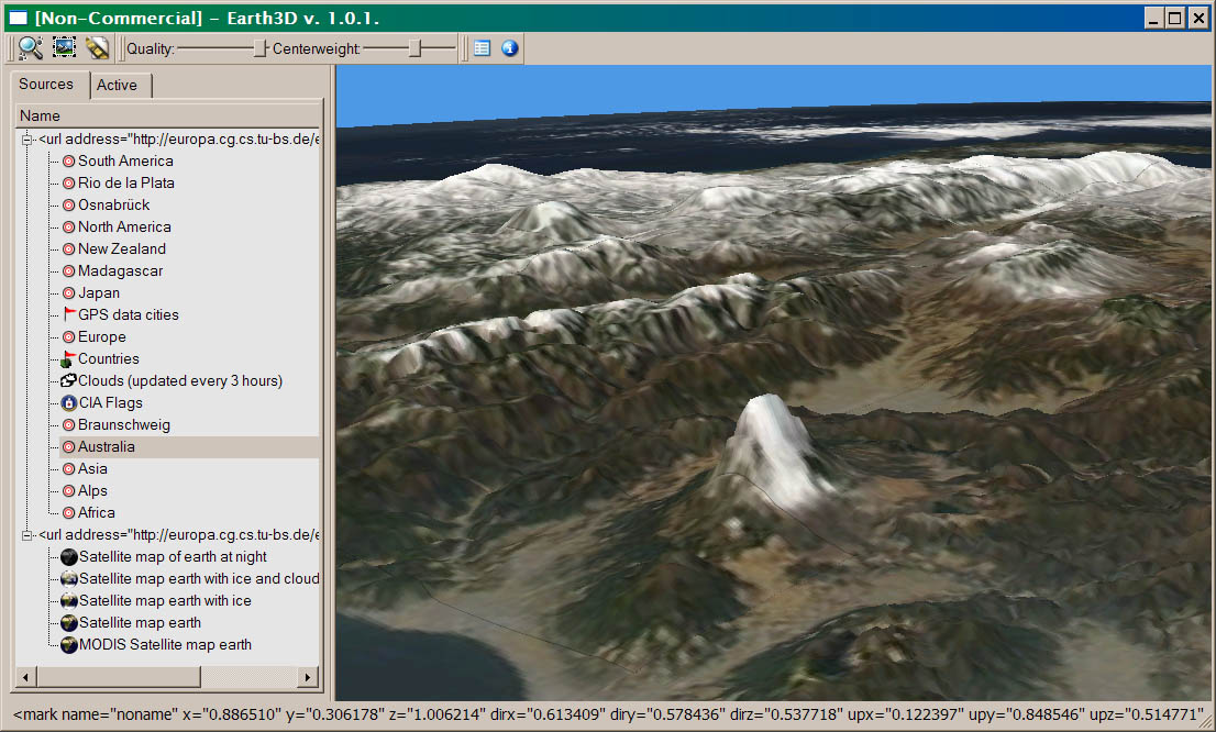
- Earth3D
-
 Earth
viewer, for elevation and imagery, streaming from its own online database
of mostly MODIS data, written by Dominique Andre Gunia of Braunschweig University
of Technology
Earth
viewer, for elevation and imagery, streaming from its own online database
of mostly MODIS data, written by Dominique Andre Gunia of Braunschweig University
of Technology
- Portable open source (GPL), source is C++ (and Java) and uses QT, binaries available for Linux, MacOSX and Windows
- tried the Windows binary v1.0.1 (on 2004.09) and found:
- Although the program works fairly well, there was a lack of caching
- turning left then right again would cause all the data to have to
be streamed down again. The elevation dataset was also very strange
(cruder than SRTM or even GTOPO).
- Apparently, to view any data besides the built-in dataset, one would
need to modify the code.
- Flight Gear Simulator
Project
- free, open-source, multi-platform, cooperative flight sim development
project
- includes a DEM-to-TIN optimization process for creating efficient meshes
(single level of detail)
- Genesis4
-
 from UK company Geomantics "The
Landscape Visualization People"
from UK company Geomantics "The
Landscape Visualization People"
- includes MapInfo and ArcView interfaces, so it can do some 3D GIS things
- grid-based, limited to 1201x1201 points
- can import multiple elevation files, but user must do manual coordinate
alignment
- so-so image quality (not comparable to other, more expensive, non-realtime
renderers)
- will texture-map terrain, but no tools for aligning imagery
- "fractalization" feature can add decent artificial detail
- g3DGVM
- open-source viewer for USGS DEM and DLG
- uses Linux with GTK+, curiously does not use OpenGL
- hftools
- a set of Unix utilities for creation and manipulation of landscape data
- can convert many different formats to PGM
-
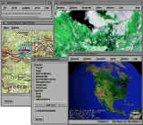
IDV (Integrated
Data Viewer
- a framework for visualizing and analyzing geoscience data, from
Unidata
- free (LGPL), runs on any platform with functional Java3D (Windows, Linux,
and Solaris/SPARC)
- 2D and 3D viewing of datasets such as numerical weather prediction model
output, weather satellite imagery, radar imagery, etc.
- Kashmir3D
- freeware Japanese non-realtime terrain renderer
- reads USGS 1-degree-DEM, GTOPO30, Japan Geographical Survey DEM, SwissTopo
RIMINI Digital Height Model, CHsystem Height Model (PMB)
- claims either Z-buffer or full raytracing, although i wasn't able to
figure out how to turn on raytracing
- has some integration with GPS devices
- LandSerf
- viewing and analysis of elevation and vector data, both 2D and 3D via
OpenGL
- written using Java 1.4 (runs on Windows, Linux and MacOSX)
- claims TIN generation and interpolation, fractal surface generation,
and feature extraction (slope, aspect, curvature)
- supported file formats: BT, DEM, EDX, GHS, GRASS formats, Mastermap
(GB Ordnance Survey) vector text files, NTF, SVG, SRTM, TerraGen, ArcInfo
formats including Ascii/Binary grids, several image formats (but not GeoTIFF),
output to VRML heightfields
-
MicroDEM / TerrainBaseII (freeware)
- features include tracing contours, calculating slope, converting
datums, and much more
- reads DEM, DTED, SDTS 1:24K DEMs, NGDC GRD98, NOS EEZ Bathymetry, USGS
ASCII CDO, GTOPO30, ETOPO5, and OS 5 or 20 km tiles
- can merge multiple files, but the interface is awkward
- Norkart Virtual Globe
- the Norkart Virtual Globe is a client-server application for displaying
very large (=global scale) terrain models
- the client uses Java and Java3D, so it works on Windows, Linux and Solaris
- current dataset uses elevation data from the
NOAA GLOBE Project
(1 km)
- in my experience, using a fast Windows machine and DSL connection, interaction
speed was reasonable but texture paging was unusably slow
- OpenEV
- 2D/3D OpenGL-based raster/vector viewer
- supports a very large number of elevation, vector and image formats
- open source and completely portable: Win32, Linux, Irix, Solaris
- OpenSkies
- claims: "The software provides an accurate virtual representation of
the real world including terrain and landmarks extracted from real geological
and cartographic databases. Cultural features and details such as urban
areas, forests, and roads are represented graphically in 3D. Using OpenSkies
environment tools, you can also create your own custom worlds to suit your
specific needs."
- installed and evaluated 00.08.27 (and again on 01.04.29)
- had great difficulty attempting to use it, documentation was minimal
and incorrect
- supposedly open-source, but the distribution didn't include any
source code
- the demo had lots of bad "flashing" artifacts, and featureless,
extremely low-res "terrain"
- sent extensive feedback to them, but got no response
-
 osgEarth
- A 3D earth, based on OSG, cross-platform and open source (LGPL).
- Instead of OSG's rigid ive paging files, has its own ".earth" format
and supports dynamic access to data source like OGC WMS.
- No binaries; you must build it from the C++ source. Does not
appear to have a user interface.
- OSM 3D /
XNavigator
- Java-based 3D application that dynamically downloads elevation (from
SRTM) and rendered road network (from OpenStreetMap) for all of Europe.
- The main 3D content is downloaded from a Web 3D Service (W3DS).
- A project of the GDI3D group
which previously aimed to visualize just the German city of Heidelberg.
- Unfortunate use of Java, painfully slow.
- ossimPlanet
- An open-source geospatial viewer built on top of
OSG,
libwms and OSSIM
- Supports a very wide variety of raster, vector, and elevation formats
- Very large and complex, requiring a
very experienced developer to build and run it.
- Terraform
- an open source (GPL) interactive height field generation and manipulation
program
- can read and write
many formats
and can create artificial terrain
- currently runs only on Unix (GTK)
- interfaces to POV-Ray to allow pretty raytraced terrain rendering
- TNTsim3D
- the TNT product line from MicroImages
Inc. contains a free 3D viewer TNTsim3D, which only views data files
(.sim) created with their commercial CAD/GIS products
- the produce line is cross-platform, but the free viewer is Windows-only
- VTP
- the Virtual Terrain Project, whose website you are on, includes a free
set of tools and runtime for importing a large range of data and creating
interactive flyovers of any part of the world - see the
software implementation branch
of this website, and the download page
- Wilbur
- freeware terrain converter and height field generator, for Win32
- reads Bryce, 1-degree DEM, GTOPO30, and various raw and image formats
- writes Bryce and several 3D modeler / image formats
In March 2011, the WebGL platform became available
for doing OpenGL directly from JavaScript in a supporting browser (Firefox>=4 or
Chrome>=10) - 3D with no plugins.
Very quickly, some geoviz applications appeared for it. Because
the software runs on the client in JavaScript, they are effectively open, and
mostly non-commercial (Cesium is a
semi-commercial alternative.)
- WebGL Globe is just
a spinny globe for canned datasets
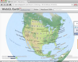
- WebGL Earth (live
demo) does paging of imagery sources (e.g. TMS), but not elevation, yet.
- OpenWebGlobe
SDK
- Can do imagery, elevation as tiled TINs, and even streamable
colorized point clouds(!)
- The demo includes a chunk of Switzerland.
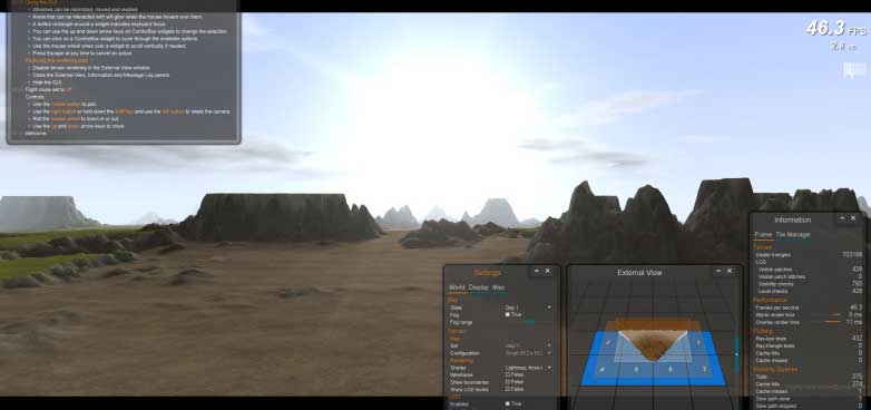
- Stavros's Project Windstorm
demo
- An impressive WebGL implementation of a smooth, tiling, well
instrumented terrain engine with a nice GUI. It uses geomipmaps
with strips or skirts, detail textures, time of day lighting with cast
shadows, and more. The issue of how to do smooth paging in JS (no
multithreading) is addressed.

- three.js is a WebGL
library that enables many projects
- Potree is a WebGL point-cloud viewer
which can handle datasets large enough (billions of points) to describe moderate terrain areas.
- Includes a converter from other pointcloud formats (like LAS/LAZ) to
its own format.
- Based on three.js. BSD
license, grew out of academic work at
TU Wien.
Older / Historical/h3>
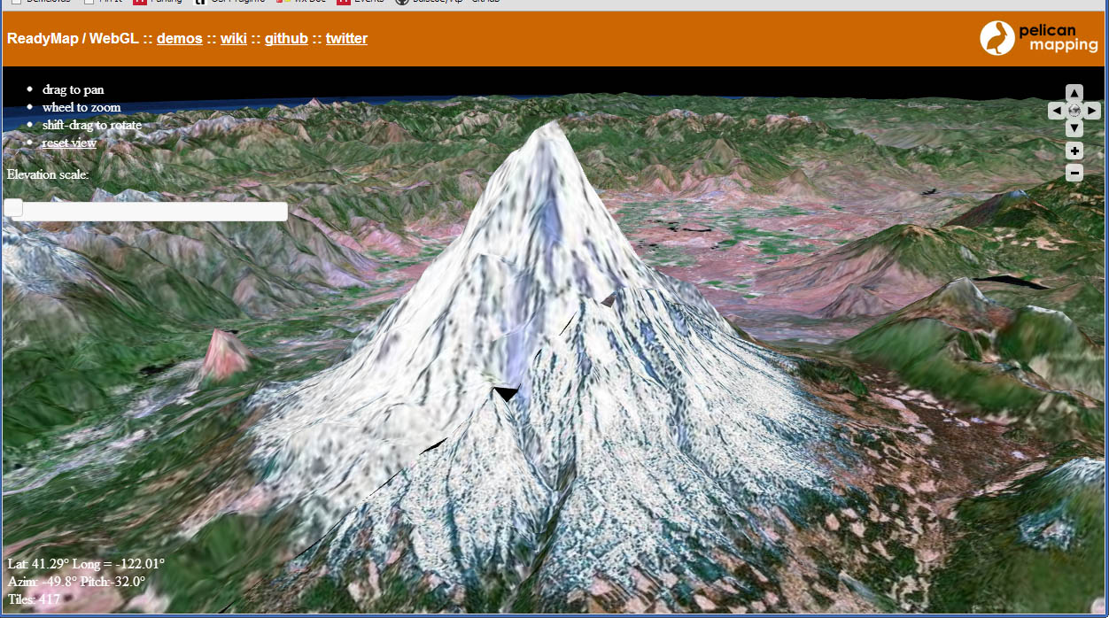
- ReadyMap (WebGL) (was call "Godzi") (from the osgEarth
people)
- An SDK for Javascript developers to embed a globe showing imagery
and a few other datatypes.
- As of 2012, it also did terrain with elevation.
- Can pull its data from common open server protocols (WMS, TMS, WFS,
KML)
-
- Alexandria Digital Earth Prototype
(ADEPT)
- the (potential) next stage of the Alexandria Digital Library project
- reportedly, the NSF announced funding from 1999-2004 - but no
mention of the actual ADEPT exists
-
BlueMarbleViewer
- open-source example application for using
OSG to render the NASA Blue
Marble earth image
- did paging of the spherical texture down to the full 1km/pixel
detail
- GRIFINOR
- Very simple open-source (LGPL) viewer, written in Java by students at
Aalborg University, Denmark.
- It doesn't quite handle terrain (no elevation?) but you can create scenes
with building block models on top of an aerial photo (must be JPEG and CRS
must be UTM). There is simple mouse navigation, and some LOD on the
building models which pops a lot.
- Was abandoned in 2006
- planet-earth.org (active 1998-2004)
- an open-source Java/VRML project, aiming for the original "digital earth"
ideals of a freely available, fully 3D world
- 3map is the "interactive
map" component,
Sourceforge: Planet Earth Project
- 3map:rez is the multiresolution
terrain management tool which takes inputs (DTED, GTOPO, BIL, ARC ASCII,
DEM, VRML ElevationGrid nodes) and writes a multiresolution LOD tree of
VRML tiles, or outputs other formats such as an image map
- they also have a few normal VRML scenes of specific locations, including
Sydney
- TerraVision
-
 there are/were actually 2 different projects by this name.
- "TerraVision Germany and TerraVision SRI started same
exact moment in time. they met each other one day and TerraVision
Germany decided to change names, in states only, to t-vision.
They were both funded similar levels, couple million, and similar details
etc. although each claims to be better."
- SRI TerraVision
- a distributed, interactive terrain visualization system that can
deal with huge datasets
- free download, main package only runs on Irix, but a plug-in viewer
works on Windows in Netscape / IE
- unfortunately, dataset creation involves primitive command-line
utilities
- as of November 2002, it became fully Open Source, but is otherwise
dormant
- ART+COM
TerraVision / T_Vision
- "a virtual representation of the whole earth as a general interface
to organize, to access and to visualize any kind of information."
- implemented on high-end SGI machines
- dormant as of around 2000
- Wissenbach Map3D (was http://www.gpstrailmaps.com/map3d/)
- open-source (GPL) GPS mapping and terrain visualization software for
Windows
- emphasis is on communication with GPS devices and handling of
GPX files
- can pull US topo and DOQ images automatically from Terraserver, and
SRTM automatically from NASA
- 3D rendering is relatively simple and limited
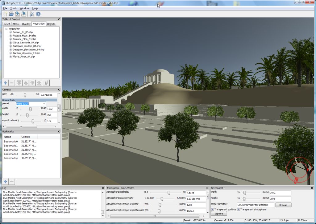 Biosphere3D